Tag Archives: maps

Gaza map comparison – Google Maps vs Microsoft Virtual Earth vs Open Street Map

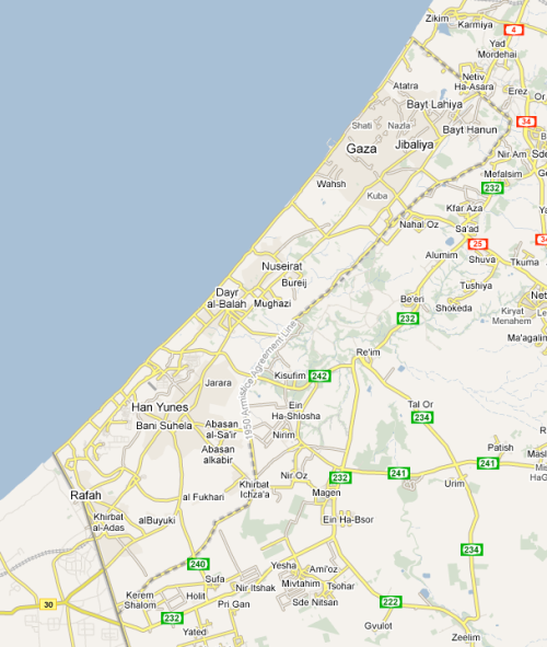
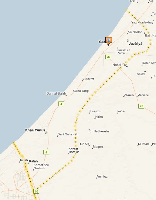
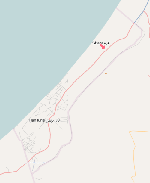
While I am not running off to the field these days I still want to what is out there for us to use.  A simple comparison between Google Maps, Microsoft Virtual Earth and Open Street Map:

Google Maps

Google Maps

Virtual Earth

Microsoft Virtual Earth

OSM

Open Street Map

Google Maps is the clear winner.  However,  when you drill down the streets have limited detail and few street names.  Still, it is nice to see that someone took the time to map a bit of Gaza and provide us with a few tools.

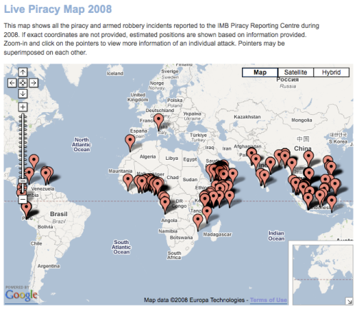
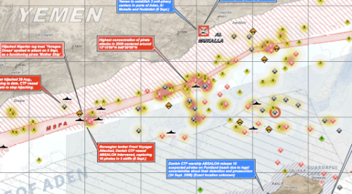
Pirate Maps

Pirate Map

I am not sure how relevant this is to the aid industry other than the fact that most attacks occur in locations where we routinely work.  The Live Piracy Map is a project of the International Chamber of Commerce’s Commercial Crime Services Division.

I once sailed through the Gulf of Aden en route from Sri Lanka to Aden aboard a 30ft sailboat.  I remember steering clear of Socotra which, at the time, was home base for many pirates.  It looks like they have decided to try their luck a little further afield.

UNOSAT

Mikel Maron mentions ‘real pirate maps’ in his latest post over at Brainoff.com.  He is referring to the latest Reliefweb/UNOSAT map that can be downloaded here.

Frank Taylor over at Google Earth Blog has a great write-up and a KML file of pirate attacks in the area.

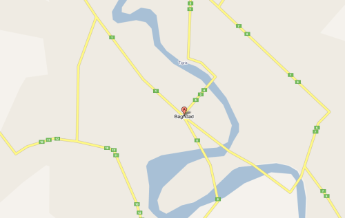
Open Street Map v. Google Maps – Baghdad

Wow.  Check out the difference.  Which map would you use?

Baghdad - Open Street Map

Baghdad - Google Maps

Baghdad - Google Maps

‘Burning Man Earth at Web 2.0 Expo’

Mikel Maron has posted the slideshows from the Web 2.0 Expo presentations he and Andrew Turner gave yesterday in NYC.  Very worthwhile clicking through with some killer pics.  Mikel and Andrew are Open Street Map evangelists and they just sold Mapufacture to Fortius One.

Read on…

New data for Georgia in Google Earth

Google Lat Long Blog

Our heart felt thanks go out to the folks in Mountain View.  Dave Barth posted yesterday over at Google Lat Long Blog to let us know that new data is now available for Georgia.  The was a minor brouhaha a few weeks back when it was noticed that there was no data for Georgia.  Dave quickly responded that they’re working on it and now, a little over two weeks later, there is a slew of new layer material.  There was a small spurt of data shortly after the very vocal uprising but now they’ve gone and added Panoramio images along with other data sets.

Thanks to Dave and the team and now we just have to ask one question: When are you posting the new Bihar imagery?

‘Google Earth – How They Do It!’

PopPhoto.com has an article on how DigitalGlobe goes about collecting imagery for Google Earth.  From the story:

When you launch GoogleEarth on your computer, you start in outer space and you miraculously zoom in. You might see two unsuspecting guys walking across the Blue Wonder Bridge way off in Dresden, Germany.

But the folks at Google Earth remind us that you’re not zooming in on just one picture. You’re actually going through a succession – seamlessly – of closer and closer shots, making the transition from a NASA shuttle shot to a satellite shot to a photograph made from an airplane. So that’s how they get such good close-up resolution.

The primary source of GoogleEarth images is, DigitalGlobe. They told Pop Photo how the system works.

Read on…

‘Alternative to Google Earth proposed at digital mapping conference’

I have been sitting on this one for a while I try to figure out if it dovetails with what I’ve been thinking about the need for a open source geobrowser which, most importantly, does not come loaded with imagery.  (Yeah, it’s that bandwidth issue again.)

The Industry Standard has a write-up on Ron Lake’s (CEO of Galdos Systems) concern over the growing dependence on private mapping systems.  From the article:

Ron Lake, CEO of digital mapping company Galdos Systems, is concerned about the world-wide dependence on private mapping systems, such as Google Earth. Lake, who wrote about the issue for the 2008 GeoWeb conference, states that digital maps are becoming an essential facet of public and government information and he thinks that it’s too important for private companies to handle alone. Instead he proposes a single, government funded virtual map of the earth.

Currently, there are a number of digital mapping systems maintained by different private companies, including Microsoft and Google. Lake believes this could lead to problems when private data is used in official capacities. For example, emergency services might need far more accurate digital maps of a specific area than a consumer-oriented online service can provide. Also, other geographic regions might resent that most of the world’s digital mapping research and collection takes place in the United States, and want information developed and centered in their own home countries.

Read on…

Mikel Maron is mapping the West Bank

Mikel Maron is doing an incredible job of mapping the West Bank and has detailed his adventures on his blog, BrainOff.  Please head over and read about what Mikel is up to.  Mikel just sold Mapufacture to Fortius One and is an Open Street Map evangelist.

Read on…

GeoEye signs deal to provide imagery to Google – Reuters

Reuters is reporting that GeoEye will soon begin providing high-resolution imagery to Google for Google Maps and Google Earth.  Here are some highlights from the article:

WASHINGTON (Reuters) – GeoEye Inc on Thursday said it will provide imagery from its new $502 million high-resolution GeoEye-1 satellite to Google Earth and Google Maps after the spacecraft is launched on September 4.

If all goes well with the launch, GeoEye’s new satellite will be the world’s highest resolution commercial earth-imaging satellite, offering images at .41 meters resolution in black and white and 1.65 meters in color.

Google spokeswoman Kate Hurowitz said Google would begin receiving half-meter resolution imagery from the new satellite after 45 to 60 days, during which the company will make sure all the satellite’s systems are up and running.

Read on…

‘QR Codes on Google Maps’

Keir Clarke over at Google Maps Mania has a write-up on generating QR Codes for Google Maps.  He suggests these three sites for creating your own QR Codes from geolocated data:

  • Semapedia.org (which we already covered in an earlier post) connects Wikipedia articles with real world locations.
  • QRMap allows you to generate a code simply by dragging and dropping a placemark on a Google Map which you then email to yourself via a link on the map.  While definitely clever I am not sure it is any more efficient than the method I describe in a previous post.
  • QR Code Mapplet is more of a marketing tool but a cool one at that.  It allows registered users to create Google Maps placemarks with embedded QR Codes for events, sales, etc.  Definitely head over and check out the demo to see what is possible.

Lastly, Keir suggests Google Chart API for those of you who want to look under the hood.

Read on…